Ghagger: Difference between revisions
Hari singh (talk | contribs) No edit summary |
No edit summary |
||
| Line 1: | Line 1: | ||
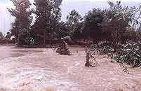
[[Image:Ghagger.jpg|thumb|300px|right|Ghagger During Flood]] | |||
The Ghaggar is a seasonal river in [[India]], flowing when water is available from monsoon rains. It originates in the Shivalik Hills of Himachal Pradesh and flows through [[Punjab]] and Haryana to Rajasthan; just southwest of [[Sirsa]] in Haryana, this seasonal river feeds two irrigation canals that extend into Rajasthan, and is thereby consumed. | The Ghaggar is a seasonal river in [[India]], flowing when water is available from monsoon rains. It originates in the Shivalik Hills of Himachal Pradesh and flows through [[Punjab]] and Haryana to Rajasthan; just southwest of [[Sirsa]] in Haryana, this seasonal river feeds two irrigation canals that extend into Rajasthan, and is thereby consumed. | ||
| Line 12: | Line 14: | ||
* [http://dswcpunjab.gov.in/homepage.htm dswcpunjab.gov.in] | * [http://dswcpunjab.gov.in/homepage.htm dswcpunjab.gov.in] | ||
[[category:rivers]] | |||
[[Category:Geography]] | [[Category:Geography]] | ||
Revision as of 05:05, 2 January 2007
The Ghaggar is a seasonal river in India, flowing when water is available from monsoon rains. It originates in the Shivalik Hills of Himachal Pradesh and flows through Punjab and Haryana to Rajasthan; just southwest of Sirsa in Haryana, this seasonal river feeds two irrigation canals that extend into Rajasthan, and is thereby consumed.
The present-day Sarasvati River originates in a submontane region (Ambala district) and joins the Ghaggar near Shatrana in PEPSU. Near Sadulgarh (Hanumangarh) the Naiwala channel, a dried out channel of the Sutlej, joins the Ghaggar. Near Suratgarh the Ghaggar is then joined by the dried up Drishadvati river.
The wide river bed of the Ghaggar river suggest that the river once flowed in great strength, and that it formerly continued through eastern Pakistan in the presently dry channel of the Hakra River, possibly emptying into the Rann of Kutch. It supposedly dried up due to the capture of its tributaries by the Indus and Ganges rivers, and the loss of rainfall in much of its catchment area due to deforestation and overgrazing. This is supposed to have happened at the latest in 1900 BCE, but perhaps much earlier.
In India there are also various small or middle-sized rivers called Sarasvati or Saraswati. One of them flows from the west end of the Aravalli Hills into the east end of the Rann of Kutch.

